Vistula Land – Russian Empire
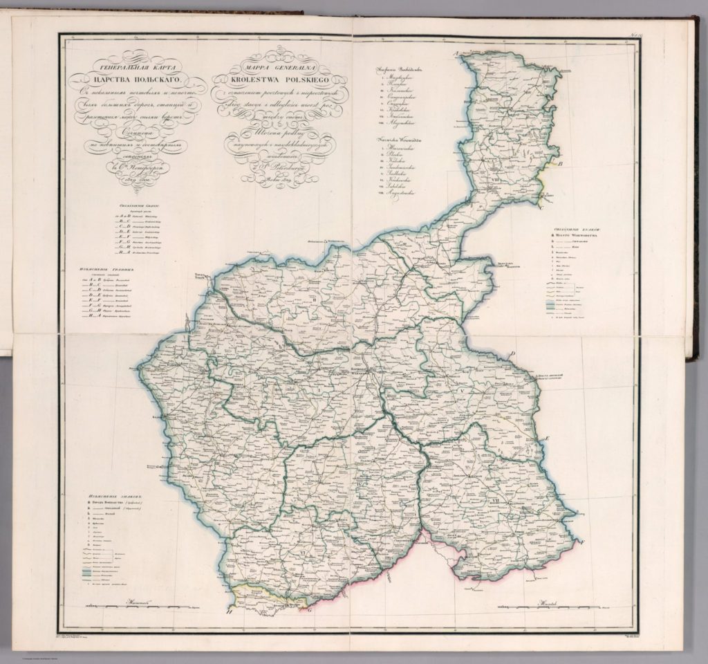
Map of the Congress Kingdom of Poland circa 1829
 Source: Piadyshev, Vasilii Petrovich. (1829). Generalnaia karta Tsarstva Polskago : S pokazaniem pochtovykh i bolshikh proezzhikh dorog, stantsii i razstoianiia mezhdu onymi verst. Sochinena po noveishim i dostovernym svedeniiam, v S-t Peterburge 1829 goda = Mappa generalna Krolestwa Polskiego. Sochinil i gravir. Piadyshev. Vyrez. slova Eremin. (to accompany) Geograficheskii atlas Rossiiskoi Imperii = Atlas geographique de l’ empire de Russie. No. 1. Image taken from: https://uwi-primoalma-prod.hosted.exlibrisgroup.com/permalink/f/ol0k7k/TN_lunaRUMSEY~8~1~288381~90060065
The Congress Kingdom of Poland was created after the third partition of Poland, where the Polish-Lithuanian Commonwealth was divided between the Russian, Prussian, and Austrian Empires in 1792 and again after the Napoleonic Wars in 1815. The country held onto some autonomy until the January Uprising in 1863, which resulted in the complete incorporation into the Russian Empire. At this point the Congress Kingdom of Poland was dissolved and renamed as the Vistula Land. All official documents after 1868 were required to be kept in the Russian language, this includes all church records (although in some cases the records were still in Polish).
The country was divided into eight administrative districts called Gubernia (Governorates) and further divided into Powiat (Provinces) that contains smaller Gmina (Districts).
The Eight Gubernia, as numbered on the map above, were:
- Mazowieckie (later known as Warszawa)
- Płock
- Kalisz
- Sandormierz
- Siedlce (later known as Podlasie)
- Kraków
- Lubliń
- Augustów
By 1893, which was around time frame that the Słownik geograficzny Królestwa Polskiego i innych krajów słowiańskich was being written and compiled, the Gubernia were:
- Warszawa
- Kalisz
- Kielce
- Łomża
- Lublin
- Piotrków
- Płock
- Radom
- Siedlce
- Suwałki
More information can be found on the Province pages on this website.
Pages
- Forum
- Home Page
- Blog Posts Page
- About Me
- Slownik Geograficzny Translations
- Vistula Land – Russian Empire
- Nieszawa County – Warszawa Gubernia, Vistula Land, Russian Empire
- Włocławek County – Warszawa Gubernia, Vistula Land, Russian Empire
- Lipno County – Warszawa Gubernia, Vistula Land, Russian Empire
- Koło County – Kalisz Gubernia, Vistula Land, Russian Empire
- Słupca County – Kalisz Gubernia, Vistula Land, Russian Empire
- Koniń County – Kalisz Gubernia, Vistula Land, Russian Empire
- Turek County – Kalisz Gubernia, Vistula Land, Russian Empire
- Kalisz County – Kalisz Gubernia, Vistula Land, Russian Empire
- Ostrołęka County – Łomża Gubernia, Vistula Land, Russian Empire
- Maków County – Łomża Gubernia, Vistula Land, Russian Empire
- Province of Posen, German Empire
- Strzelno County – Posen, German Empire
- Inowrocław County – Posen, German Empire
- Mogilno County – Posen, German Empire
- Wyrzysk County – Posen, German Empire
- Chodzież County – Posen, German Empire
- Wągrowiec County – Posen, German Empire
- Szubin County – Posen, German Empire
- Żnin County – Posen, German Empire
- Września County – Posen, German Empire
- Pleszew County – Posen, German Empire
- Province of West Prussia, German Empire
- Kociewe Region Research
- Links
- Disclaimer
Categories
Blog Post Calendar
| M | T | W | T | F | S | S |
|---|---|---|---|---|---|---|
| 1 | 2 | 3 | ||||
| 4 | 5 | 6 | 7 | 8 | 9 | 10 |
| 11 | 12 | 13 | 14 | 15 | 16 | 17 |
| 18 | 19 | 20 | 21 | 22 | 23 | 24 |
| 25 | 26 | 27 | 28 | 29 | 30 | |

